Jigme Singye Wangchuk National Park.
Black Mountain National Park
Jigme Singye Wangchuk National Park covers an area of 1,730 square kilometres (670 sq mi) in central Bhutan. The Park occupies most of Trongsa District, as well as parts of,Sarpang, Tsring, Wangdue Phodrang and Zhemgang Districts. The Park is bound to the east by the Mangdue chhu and reaches the Wang chhu to the west. Along the border of the Park from the north to the southeast run Bhutan's main east-west and north-south highways. It is also connected via "biological corridors" to other national parks in northern, eastern, central, and southern Bhutan.
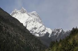
With elevations spanning from 600 metres (2,000 ft) to 4,925 metres (16,158 ft), the Park includes a wide range of biomes: broadleaf and coniferous forests,alpine pastures and lakes, and even the snow cap on the peak of Jou Dorshingla.It is the largest and most intact temperate forest reserve in the entire Himalaya. It is home thundreds of species of birds, including the endangered Black Necked Crane.About 6,000 people reside in the Jigme Singye Wangchuck National Park, while about 15,000 live in the immediate environs, mostly practicing agriculture and raising livestock.
With elevations spanning from 600 metres (2,000 ft) to 4,925 metres (16,158 ft), the Park includes a wide range of biomes: broadleaf and coniferous forests,alpine pastures and lakes, and even the snow cap on the peak of Jou Dorshingla.It is the largest and most intact temperate forest reserve in the entire Himalaya. It is home thundreds of species of birds, including the endangered Black Necked Crane.About 6,000 people reside in the Jigme Singye Wangchuck National Park, while about 15,000 live in the immediate environs, mostly practicing agriculture and raising livestock.
